Pick Up Technologies
Disaster Information Sharing System

Principal Researcher
Consolidation and sharing of diverse disaster information
Along with global climate change, Japan too has been hit by severe natural disasters practically every year. In addition, the probability of a major Nankai Trough earthquake occurring within the next 30 years is said to be 80%. For a disaster-prone country like Japan, formulating a business continuity plan (BCP) as a countermeasure to such disasters is essential to business enterprises. In addition to insuring the survival of a company, drawing up a BCP will make the company robust to disasters thereby increasing the value of the company and contributing to the local community. For these reasons, we developed a “Disaster Information Sharing System” that is useful for both formulating and executing a BCP.
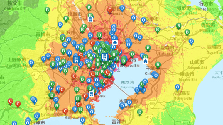
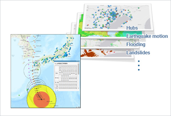
This Disaster Information Sharing System combines internal information from company hubs with information issued by outside institutions such as the National Research Institute for Earth Science and Disaster Resilience (NIED), extracts useful information, and provides that information in an easy-to-understand manner. This system consists of an “earthquake bulletin system” that sends out mail immediately after the occurrence of an earthquake and an “online hazard map” that can display prior hazard information and the damage situation following the occurrence of a disaster for points of concern. This hazard information includes seismic intensity for an envisioned earthquake, risk of liquefaction, maximum inundation depth of a tsunami and high tides caused by a typhoon, maximum inundation depth of flooding, and areas at risk of landslide. The online hazard map is useful for verifying various types of hazard information at specific points during normal times and for formulating a BCP. It can be used to verify rainfall conditions and weather information (rainfall, wind, heatstroke) for up to 72 hours in advance, typhoon paths, etc. in real time. It can also be used to check estimated seismic intensity on a map for registered points in about 20 minutes after an earthquake strikes. As a result, which areas will likely have major damage can be understood at a glance, which can help in drawing up the best initial response plans to aid in disaster recovery. The map can also display routes for transporting supplies for an envisioned earthquake as well as transport distances and transport times to support swift recovery activities, and it can send out mail that provides estimations of structural damage to buildings. This information can be checked anytime and anywhere enabling a speedy response to earthquakes whose time of arrival is unknown. In addition to its use in making an effective plan for such an initial response, this information can also serve as reliable material for determining what response should be taken immediately after the occurrence of a relatively small earthquake on the basis of structural damage estimates.
Important Facts
Display of disaster information
Displays information on hub locations, earthquake motion, flooding, landslides, weather (rainfall, strong winds, heat stroke, typhoon paths), etc. on maps in an easy-to-understand manner that is useful for formulating a BCP and disaster recovery plan.
Expected Application Fields
- Disaster Prevention
- Business Continuity Plan
- Geographic Information System